Sierndorf
Sierndorf | |
|---|---|
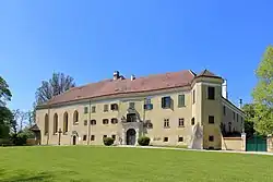 Sierndorf Castle | |
 Coat of arms | |
 Sierndorf Location within Austria | |
| Coordinates: 48°26′N 16°10′E / 48.433°N 16.167°E | |
| Country | Austria |
| State | Lower Austria |
| District | Korneuburg |
| Government | |
| • Mayor | Gottfried Muck (ÖVP) |
| Area | |
• Total | 55.08 km2 (21.27 sq mi) |
| Elevation | 191 m (627 ft) |
| Population (2018-01-01)[2] | |
• Total | 3,933 |
| • Density | 71/km2 (180/sq mi) |
| Time zone | UTC+1 (CET) |
| • Summer (DST) | UTC+2 (CEST) |
| Postal code | 2011 |
| Area code | 02267 |
| Website | www.sierndorf.at |
Sierndorf is a town in the district of Korneuburg in the Austrian state of Lower Austria.
Population
| Year | Pop. | ±% |
|---|---|---|
| 1869 | 2,639 | — |
| 1880 | 2,805 | +6.3% |
| 1890 | 3,137 | +11.8% |
| 1900 | 3,139 | +0.1% |
| 1910 | 3,033 | −3.4% |
| 1923 | 2,995 | −1.3% |
| 1934 | 2,876 | −4.0% |
| 1939 | 3,021 | +5.0% |
| 1951 | 2,735 | −9.5% |
| 1961 | 2,502 | −8.5% |
| 1971 | 2,413 | −3.6% |
| 1981 | 2,589 | +7.3% |
| 1991 | 2,786 | +7.6% |
| 2001 | 3,132 | +12.4% |
| 2011 | 3,634 | +16.0% |
| 2021 | 3,986 | +9.7% |
References
- ^ "Dauersiedlungsraum der Gemeinden Politischen Bezirke und Bundesländer - Gebietsstand 1.1.2018". Statistics Austria. Retrieved 10 March 2019.
- ^ "Einwohnerzahl 1.1.2018 nach Gemeinden mit Status, Gebietsstand 1.1.2018". Statistics Austria. Retrieved 9 March 2019.