Simmerath
Simmerath | |
|---|---|
 | |
 Flag  Coat of arms | |
Location of Simmerath within Aachen district .svg.png) | |
 Simmerath  Simmerath | |
| Coordinates: 50°36′25″N 6°18′00″E / 50.60694°N 6.30000°E | |
| Country | Germany |
| State | North Rhine-Westphalia |
| Admin. region | Köln |
| District | Aachen |
| Subdivisions | 17 |
| Government | |
| • Mayor (2020–25) | Bernd Goffart[1] (CDU) |
| Area | |
• Total | 110.92 km2 (42.83 sq mi) |
| Highest elevation | 560 m (1,840 ft) |
| Lowest elevation | 280 m (920 ft) |
| Population (2023-12-31)[2] | |
• Total | 16,585 |
| • Density | 150/km2 (390/sq mi) |
| Time zone | UTC+01:00 (CET) |
| • Summer (DST) | UTC+02:00 (CEST) |
| Postal codes | 52152 |
| Dialling codes | 02473 |
| Vehicle registration | AC, MON |
| Website | www.simmerath.de |
Simmerath (German pronunciation: [ˈzɪməʁaːt]) is a municipality in the district of Aachen, in North Rhine-Westphalia, Germany. It is located approximately 20 km south-east of Aachen, near the border to Belgium.
The administrative area was expanded in 1972 and includes the following localities:
- Dedenborn
- Eicherscheid
- Einruhr
- Erkensruhr
- Hammer
- Hirschrott
- Huppenbroich
- Kesternich
- Lammersdorf
- Paustenbach
- Rollesbroich
- Rurberg
- Witzerath
- Woffelsbach
Gallery
-
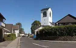
 Lammersdorf, catholic church in the street
 -
 Einruhr, church of St. Nicholas in the village
 -
 near Einruhr, river Rur
 -
 Paustenbach, view of a street
References
- ^ Wahlergebnisse in NRW Kommunalwahlen 2020, Land Nordrhein-Westfalen, accessed 19 June 2021.
- ^ "Bevölkerung der Gemeinden Nordrhein-Westfalens am 31. Dezember 2023 – Fortschreibung des Bevölkerungsstandes auf Basis des Zensus vom 9. Mai 2011" (in German). Landesbetrieb Information und Technik NRW. Retrieved 2025-04-27.
External links
![]() Media related to Simmerath at Wikimedia Commons
Media related to Simmerath at Wikimedia Commons
Towns and municipalities in Aachen district | ||
|---|---|---|
 | ||