Simmler, California
Simmler, California | |
|---|---|
 Simmler, California  Simmler, California | |
| Coordinates: 35°21′05″N 119°59′13″W / 35.35139°N 119.98694°W | |
| Country | United States |
| State | California |
| County | San Luis Obispo |
| Elevation | 2,047 ft (624 m) |
| Time zone | UTC-8 (Pacific (PST)) |
| • Summer (DST) | UTC-7 (PDT) |
| Area codes | 805 & 820 |
| GNIS feature ID | 252982[1] |
Simmler is an unincorporated community in San Luis Obispo County, California, United States. The community is on California State Route 58 38 miles (61 km) east of San Luis Obispo.[2]
See also
References
- ^ "Simmler". Geographic Names Information System. United States Geological Survey, United States Department of the Interior.
- ^ California Department of Transportation (2005). State Highway Map 2005 (Map). Retrieved June 6, 2019 – via David Rumsey Historical Map Collection.
Municipalities and communities of San Luis Obispo County, California, United States | ||
|---|---|---|
| Cities | 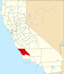 | |
| CDPs | ||
| Unincorporated communities | ||
| Ghost towns | ||