Skorradalshreppur
Skorradalshreppur | |
|---|---|
.jpg) Skyline of Skorradalshreppur | |
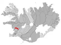 Location of the municipality | |
 Skorradalshreppur | |
| Coordinates: 64°30′18″N 21°27′53″W / 64.50500°N 21.46472°W | |
| Country | Iceland |
| Region | Western Region |
| Constituency | Northwest Constituency |
| Area | |
• Total | 216 km2 (83 sq mi) |
| Population | |
• Total | 75 |
| • Density | 0.27/km2 (0.7/sq mi) |
| Municipal number | 3506 |
| Website | skorradalur |
Skorradalshreppur (Icelandic pronunciation: [ˈskɔrːaˌtalsˌr̥ehpʏr̥] ⓘ) is a municipality in Iceland.[1]
References
- ^ "GeoNames.org". www.geonames.org. Retrieved 2023-12-02.