Slavkovský štít
| Slavkovský štít | |
|---|---|
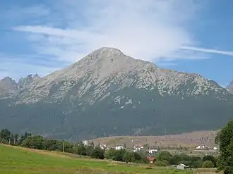 Slavkovský štít viewed from Nová Lesná | |
| Highest point | |
| Elevation | 2,452 m (8,045 ft) |
| Prominence | 225 m (738 ft) |
| Coordinates | 49°9′58″N 20°11′5″E / 49.16611°N 20.18472°E |
| Geography | |
 Slavkovský štít Location in Slovakia | |
| Location | Tatra National Park, Poprad, Prešov, Slovakia |
| Parent range | High Tatras |
| Geology | |
| Mountain type | granite |
| Climbing | |
| Easiest route | hike |
Slavkovský štít is the fourth highest mountain peak that can be reached on a marked trail in the High Tatra mountains in Slovakia. Its summit is 2452 metres above sea level. It can be reached by foot on a walking trail in about four and a half hours from Starý Smokovec. The first recorded ascent was by Juraj Buchholtz in 1664 and it took the group of 12 members 2 days; only 4 of them reached the summit.[1]
In the 19th century it was considered to build Observatory and Meteorological Station on the summit together with a lift going up from Starý Smokovec. The project turned out to be technically unrealistic.[2]
References
- ^ Renáta Nározná; Colin Saunders (27 July 2012). The High Tatras: Slovakia and Poland - Including the Western Tatras and White Tatras. Cicerone Press Limited. pp. 185–. ISBN 978-1-84965-486-9.
- ^ Mrázik, Fero (2014-07-24). "350 rokov od prvého výstupu na Slavkovský štít". TatryPortal.sk (in Slovak). Retrieved 2020-12-03.
Wikimedia Commons has media related to Slavkovský štít.