Slocan River
| Slocan River | |
|---|---|
 | |
| Location | |
| Country | Canada |
| Province | British Columbia |
| District | Kootenay Land District |
| Physical characteristics | |
| Source | Slocan Lake |
| Mouth | Kootenay River |
• coordinates | 49°25′N 117°31′W / 49.417°N 117.517°W[3] |
| Length | 60 km (37 mi)[1] |
| Basin size | 3,290 km2 (1,270 sq mi)[1] |
| Discharge | |
| • location | Near Crescent Valley[2] |
| • average | 89.1 m3/s (3,150 cu ft/s)[2] |
| • minimum | 8.5 m3/s (300 cu ft/s) |
| • maximum | 694 m3/s (24,500 cu ft/s) |
The Slocan River is a 60-kilometre (37 mi) long[1] tributary of the Kootenay River in the Canadian province of British Columbia. It is part of the Columbia River basin, as the Kootenay River is a tributary of the Columbia River. Its drainage basin is 3,290 square kilometres (1,270 sq mi) in area.[1]
Course
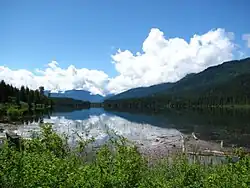
The Slocan River originates at the south end of Slocan Lake[3] and flows south past Slocan and Winlaw to join the Kootenay River near Shoreacres, about halfway between Castlegar and Nelson. The route includes a mixture of broad flatwater, lazy meanders, gentle flows and, on the lowest section, a few rapids.
See also
- List of rivers of British Columbia
- Tributaries of the Columbia River
 Media related to Slocan River at Wikimedia Commons
References
- ^ a b c d "The Rivers - Stories". Balance of Power. 2007. Archived from the original on November 6, 2011. Retrieved September 3, 2008.
- ^ a b "Archived Hydrometric Data Search". Water Survey of Canada. Archived from the original on April 30, 2006. Retrieved October 19, 2008. Search for Station 08NJ013 Slocan River near Crescent Valley
- ^ a b "Slocan River". BC Geographical Names.