Sorgues (river)
| Sorgue | |
|---|---|
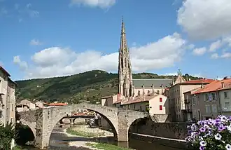 The Sorgues at Saint-Affrique | |
  | |
| Location | |
| Country | France |
| Physical characteristics | |
| Source | |
| • location | Cornus |
| • coordinates | 43°52′34″N 03°12′22″E / 43.87611°N 3.20611°E |
| • elevation | 600 m (2,000 ft) |
| Mouth | Dourdou de Camarès |
• coordinates | 43°57′20″N 02°50′12″E / 43.95556°N 2.83667°E |
• elevation | 298 m (978 ft) |
| Length | 46.4 km (28.8 mi) |
| Basin size | 279 km2 (108 sq mi) |
| Discharge | |
| • average | 4.38 m3/s (155 cu ft/s) |
| Basin features | |
| Progression | Dourdou de Camarès→ Tarn→ Garonne→ Gironde estuary→ Atlantic Ocean |
The Sorgue (French: la Sorgue, also called Sorgue, French pronunciation: [sɔʁg]; Occitan: Sòrga) is a 46.4-kilometre-long (28+13⁄16 mi) river in the Aveyron department in Southern France.[1] Its source is a karstic spring at Fontaine de Valcluse, in Provence. See also “Sorgue.”
Communes along its course
This list is ordered from source to mouth: Cornus, Fondamente, Marnhagues-et-Latour, Saint-Félix-de-Sorgues, Versols-et-Lapeyre, Saint-Affrique, Vabres-l'Abbaye
References
Wikimedia Commons has media related to Sorgues.