South Carolina Highway 245
 South Carolina Highway 245 | ||||
|---|---|---|---|---|
 | ||||
| Route information | ||||
| Maintained by SCDOT | ||||
| Length | 5.060 mi[1] (8.143 km) | |||
| Existed | 1931–present | |||
| Major junctions | ||||
| South end | ||||
| North end | ||||
| Location | ||||
| Country | United States | |||
| State | South Carolina | |||
| Counties | Lexington | |||
| Highway system | ||||
| ||||
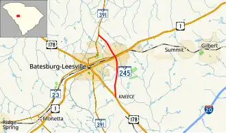
South Carolina Highway 245 (SC 245) is a 5.060-mile-long (8.143 km) state highway in the U.S. state of South Carolina. The highway was built and paved in 1932 as a short spur of SC 24 passing north through Leesville to connect with SC 391.[2] Since being built, that section of SC 24 was redesignated as US 178 in 1933, and Leesville merged in 1992 with Batesburg, where US 1 and SC 391 intersect, to form the town of Batesburg-Leesville. It is known locally as North Lee Street north of the railroad tracks, and as South Lee Street south of the railroad tracks. There are two traffic lights along SC 245.[3]
Major intersections
The entire route is in Lexington County.
| Location | mi[1] | km | Destinations | Notes | |
|---|---|---|---|---|---|
| | 0.000 | 0.000 | Southern terminus | ||
| Batesburg-Leesville | 2.980 | 4.796 | |||
| 3.100 | 4.989 | ||||
| | 5.060 | 8.143 | |||
| 1.000 mi = 1.609 km; 1.000 km = 0.621 mi | |||||
See also
References
- ^ a b "Highway Logmile Report". South Carolina Department of Transportation. Retrieved December 26, 2020.
- ^ General Highway System - Lexington County, South Carolina (PDF) (Map). South Carolina Department of Transportation. August 2005. Retrieved February 2, 2013.
- ^ "South Carolina Highway 245" (Map). Google Maps. Retrieved February 2, 2013.
External links
Template:Attached KML/South Carolina Highway 245
KML is from Wikidata
Wikimedia Commons has media related to South Carolina Highway 245.