South Carolina Highway 83
 South Carolina Highway 83 | ||||
|---|---|---|---|---|
 | ||||
| Route information | ||||
| Maintained by SCDOT | ||||
| Length | 4.820 mi[1] (7.757 km) | |||
| Existed | 1938–present | |||
| Major junctions | ||||
| South end | ||||
| North end | ||||
| Location | ||||
| Country | United States | |||
| State | South Carolina | |||
| Counties | Marlboro | |||
| Highway system | ||||
| ||||
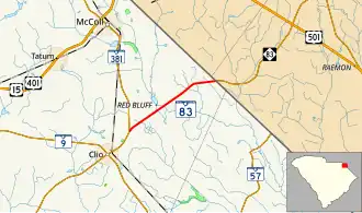
South Carolina Highway 83 (SC 83) is a 4.820-mile (7.757 km) primary state highway in the U.S. state of South Carolina. It connects the communities of eastern Marlboro County with Maxton, North Carolina.
Route description
SC 83 is a two-lane rural highway that traverses from a point northeast of Clio at SC 381 to the North Carolina state line where the road continues as North Carolina Highway 83 (NC 83).[2][3]
History
The highway was established in 1938 as a renumbering of SC 68 to match NC 83; no changes have been made since.[4]
Major intersections
The entire route is in Marlboro County.
| Location | mi[1] | km | Destinations | Notes | |
|---|---|---|---|---|---|
| | 0.000 | 0.000 | |||
| | 4.820 | 7.757 | North Carolina state line | ||
| 1.000 mi = 1.609 km; 1.000 km = 0.621 mi | |||||
See also
References
- ^ a b "Highway Logmile Report". South Carolina Department of Transportation. Retrieved December 24, 2020.
- ^ "Overview map of SC 83" (Map). Google Maps. Retrieved September 5, 2012.
- ^ General Highway System - Marlboro County, South Carolina (PDF) (Map). South Carolina Department of Transportation. June 2005. Retrieved September 7, 2013.
- ^ "SC 83". Virginia Highways' South Carolina Highways Annex. Retrieved September 5, 2012.
External links
Template:Attached KML/South Carolina Highway 83
KML is from Wikidata
 Media related to South Carolina Highway 83 at Wikimedia Commons