Srnín
Srnín | |
|---|---|
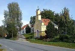 Chapel by the main road | |
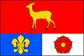 Flag 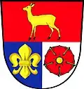 Coat of arms | |
 Srnín Location in the Czech Republic | |
| Coordinates: 48°50′42″N 14°20′37″E / 48.84500°N 14.34361°E | |
| Country | |
| Region | South Bohemian |
| District | Český Krumlov |
| First mentioned | 1400 |
| Area | |
• Total | 6.72 km2 (2.59 sq mi) |
| Elevation | 540 m (1,770 ft) |
| Population (2025-01-01)[1] | |
• Total | 366 |
| • Density | 54/km2 (140/sq mi) |
| Time zone | UTC+1 (CET) |
| • Summer (DST) | UTC+2 (CEST) |
| Postal code | 381 01 |
| Website | www |
Srnín is a municipality and village in Český Krumlov District in the South Bohemian Region of the Czech Republic. It has about 400 inhabitants.
Srnín lies approximately 5 kilometres (3 mi) north of Český Krumlov, 18 km (11 mi) south-west of České Budějovice, and 138 km (86 mi) south of Prague.
Demographics
| Year | Pop. | ±% |
|---|---|---|
| 1869 | 209 | — |
| 1880 | 227 | +8.6% |
| 1890 | 245 | +7.9% |
| 1900 | 273 | +11.4% |
| 1910 | 265 | −2.9% |
| 1921 | 273 | +3.0% |
| 1930 | 269 | −1.5% |
| 1950 | 222 | −17.5% |
| 1961 | 222 | +0.0% |
| 1970 | 212 | −4.5% |
| 1980 | 207 | −2.4% |
| 1991 | 192 | −7.2% |
| 2001 | 224 | +16.7% |
| 2011 | 311 | +38.8% |
| 2021 | 323 | +3.9% |
| Source: Censuses[2][3] | ||
References
- ^ "Population of Municipalities – 1 January 2025". Czech Statistical Office. 2025-05-16.
- ^ "Historický lexikon obcí České republiky 1869–2011" (in Czech). Czech Statistical Office. 2015-12-21.
- ^ "Population Census 2021: Population by sex". Public Database. Czech Statistical Office. 2021-03-27.
External links
Wikimedia Commons has media related to Srnín.