Střítež pod Křemešníkem
Střítež pod Křemešníkem | |
|---|---|
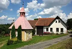 Chapel | |
 Flag  Coat of arms | |
 Střítež pod Křemešníkem Location in the Czech Republic | |
| Coordinates: 49°26′3″N 15°19′13″E / 49.43417°N 15.32028°E | |
| Country | |
| Region | Vysočina |
| District | Pelhřimov |
| First mentioned | 1379 |
| Area | |
• Total | 3.74 km2 (1.44 sq mi) |
| Elevation | 584 m (1,916 ft) |
| Population (2025-01-01)[1] | |
• Total | 64 |
| • Density | 17/km2 (44/sq mi) |
| Time zone | UTC+1 (CET) |
| • Summer (DST) | UTC+2 (CEST) |
| Postal code | 393 01 |
| Website | www |
Střítež pod Křemešníkem is a municipality and village in Pelhřimov District in the Vysočina Region of the Czech Republic. It has about 60 inhabitants.
Střítež pod Křemešníkem lies approximately 8 kilometres (5 mi) east of Pelhřimov, 21 km (13 mi) west of Jihlava, and 98 km (61 mi) south-east of Prague.
Demographics
| Year | Pop. | ±% |
|---|---|---|
| 1869 | 205 | — |
| 1880 | 211 | +2.9% |
| 1890 | 223 | +5.7% |
| 1900 | 225 | +0.9% |
| 1910 | 198 | −12.0% |
| 1921 | 229 | +15.7% |
| 1930 | 207 | −9.6% |
| 1950 | 151 | −27.1% |
| 1961 | 130 | −13.9% |
| 1970 | 98 | −24.6% |
| 1980 | 78 | −20.4% |
| 1991 | 56 | −28.2% |
| 2001 | 42 | −25.0% |
| 2011 | 45 | +7.1% |
| 2021 | 63 | +40.0% |
| Source: Censuses[2][3] | ||
References
- ^ "Population of Municipalities – 1 January 2025". Czech Statistical Office. 2025-05-16.
- ^ "Historický lexikon obcí České republiky 1869–2011" (in Czech). Czech Statistical Office. 2015-12-21.
- ^ "Population Census 2021: Population by sex". Public Database. Czech Statistical Office. 2021-03-27.
External links
Wikimedia Commons has media related to Střítež pod Křemešníkem.