Stafford Township, Greene County, Indiana
Stafford Township | |
|---|---|
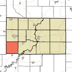 Location in Greene County | |
| Coordinates: 38°56′55″N 87°10′37″W / 38.94861°N 87.17694°W | |
| Country | United States |
| State | Indiana |
| County | Greene |
| Government | |
| • Type | Indiana township |
| Area | |
• Total | 35.97 sq mi (93.2 km2) |
| • Land | 35.82 sq mi (92.8 km2) |
| • Water | 0.16 sq mi (0.4 km2) 0.44% |
| Elevation | 505 ft (154 m) |
| Population (2020) | |
• Total | 411 |
| • Density | 11/sq mi (4.4/km2) |
| GNIS feature ID | 0453869 |
Stafford Township is one of fifteen townships in Greene County, Indiana, USA. As of the 2020 census, its population was 411,[1] down from 448 at 2010.[2]
| Census | Pop. | Note | %± |
|---|---|---|---|
| 1890 | 1,304 | — | |
| 1900 | 1,529 | 17.3% | |
| 1910 | 1,322 | −13.5% | |
| 1920 | 1,297 | −1.9% | |
| 1930 | 1,145 | −11.7% | |
| 1940 | 1,065 | −7.0% | |
| 1950 | 853 | −19.9% | |
| 1960 | 730 | −14.4% | |
| 1970 | 535 | −26.7% | |
| 1980 | 590 | 10.3% | |
| 1990 | 493 | −16.4% | |
| 2000 | 490 | −0.6% | |
| 2010 | 448 | −8.6% | |
| 2020 | 411 | −8.3% | |
| Source: US Decennial Census[3] | |||
Geography
According to the 2010 census, the township has a total area of 35.97 square miles (93.2 km2), of which 35.82 square miles (92.8 km2) (or 99.58%) is land and 0.16 square miles (0.41 km2) (or 0.44%) is water.[2]
Unincorporated towns
(This list is based on USGS data and may include former settlements.)
Adjacent townships
- Stockton Township (north)
- Grant Township (northeast)
- Washington Township (east)
- Vigo Township, Knox County (south)
- Jefferson Township, Sullivan County (west)
Major highways
References
- ^ "Explore Census Data". data.census.gov. Retrieved April 8, 2024.
- ^ a b "Population, Housing Units, Area, and Density: 2010 - County -- County Subdivision and Place -- 2010 Census Summary File 1". United States Census. Archived from the original on February 10, 2020. Retrieved May 10, 2013.
- ^ "Township Census Counts: STATS Indiana".
External links
Municipalities and communities of Greene County, Indiana, United States | ||
|---|---|---|
| Cities | 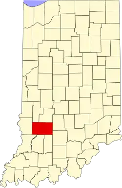 | |
| Towns | ||
| Townships | ||
| CDPs | ||
| Other communities | ||
| Footnotes | ‡This populated place also has portions in an adjacent county or counties | |