Steinfeld, Lower Saxony
Steinfeld | |
|---|---|
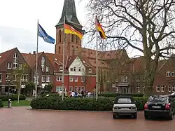 Town centre | |
_COA.svg.png) Coat of arms | |
Location of Steinfeld within Vechta district _in_VEC.svg.png) | |
 Steinfeld 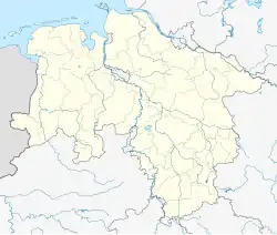 Steinfeld | |
| Coordinates: 52°36′N 8°13′E / 52.600°N 8.217°E | |
| Country | Germany |
| State | Lower Saxony |
| District | Vechta |
| Subdivisions | 10 districts |
| Government | |
| • Mayor | Max Bernd Trumme (GFG) (Ind.) |
| Area | |
• Total | 60.05 km2 (23.19 sq mi) |
| Elevation | 47 m (154 ft) |
| Population (2023-12-31)[1] | |
• Total | 10,211 |
| • Density | 170/km2 (440/sq mi) |
| Time zone | UTC+01:00 (CET) |
| • Summer (DST) | UTC+02:00 (CEST) |
| Postal codes | 49439 |
| Dialling codes | 05492 |
| Vehicle registration | VEC |
| Website | www.steinfeld.de |
Steinfeld (German pronunciation: [ˈʃtaɪnˌfɛlt]) is a municipality in the district of Vechta, in Lower Saxony, Germany. It is situated approximately 16 km southwest of Vechta, and 40 km northeast of Osnabrück.
Wikimedia Commons has media related to Steinfeld, Lower Saxony.
References
Towns and municipalities in Vechta (district) | ||
|---|---|---|
 | ||