Steiri
Steiri
Στείρι | |
|---|---|
 Steiri | |
 Steiri | |
| Coordinates: 38°24′N 22°42′E / 38.400°N 22.700°E | |
| Country | Greece |
| Administrative region | Central Greece |
| Regional unit | Boeotia |
| Municipality | Distomo-Arachova-Antikyra |
| Municipal unit | Distomo |
| Highest elevation | 1,000 m (3,000 ft) |
| Lowest elevation | 440 m (1,440 ft) |
| Population (2021)[1] | |
• Community | 559 |
| Time zone | UTC+2 (EET) |
| • Summer (DST) | UTC+3 (EEST) |
| Postal code | 321 00 |
| Area code(s) | 26940 |
| Vehicle registration | BI |
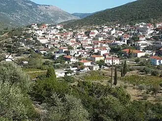
Steiri (Greek: Στείρι) is a village in Boeotia, Greece. It is situated at the western end of Mount Helicon, the mythical mountain of the Muses, at 450 m elevation. The 10th century Hosios Loukas monastery, a World Heritage Site, is situated near Steiri. Steiri is 4 km southeast of Distomo and 15 km west of Livadeia. The Greek National Road 29 (Itea - Desfina - Distomo - Hosios Loukas) passes through the village.
Population
| Year | Population |
|---|---|
| 1981 | 942 |
| 1991 | 914 |
| 2001 | 1,010 |
| 2011 | 686 |
| 2021 | 559 |
People
- Nicholas the Pilgrim, Christian saint and hermit, was born here around 1075/1076[2]
References
- ^ "Αποτελέσματα Απογραφής Πληθυσμού - Κατοικιών 2021, Μόνιμος Πληθυσμός κατά οικισμό" [Results of the 2021 Population - Housing Census, Permanent population by settlement] (in Greek). Hellenic Statistical Authority. 29 March 2024.
- ^ Slootjes, Daniëlle; Verhoeven, Mariette (25 March 2019). Byzantium in Dialogue with the Mediterranean History and Heritage. Brill. pp. 124–126. ISBN 9789004393585. Retrieved 4 July 2023.
External links
Wikimedia Commons has media related to Steiri.