Stonecoal, West Virginia
Stonecoal, West Virginia | |
|---|---|
 Stonecoal, West Virginia  Stonecoal, West Virginia | |
| Coordinates: 37°53′00″N 82°25′04″W / 37.88333°N 82.41778°W | |
| Country | United States |
| State | West Virginia |
| County | Wayne |
| Elevation | 630 ft (190 m) |
| Time zone | UTC-5 (Eastern (EST)) |
| • Summer (DST) | UTC-4 (EDT) |
| Area codes | 304 & 681 |
| GNIS feature ID | 1547462[1] |
Stonecoal is an unincorporated community in Wayne County, West Virginia, United States. Stonecoal is located on the Tug Fork and U.S. Route 52, 2.8 miles (4.5 km) north of Kermit.[2]
References
- ^ U.S. Geological Survey Geographic Names Information System: Stonecoal, West Virginia
- ^ Wayne County, West Virginia General Highway Map (PDF) (Map). West Virginia Department of Transportation. 2011. p. 3. Retrieved December 12, 2011.
Municipalities and communities of Wayne County, West Virginia, United States | ||
|---|---|---|
| Cities | 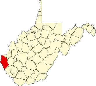 | |
| Towns | ||
| CDPs | ||
| Unincorporated communities |
| |
| Footnotes | ‡This populated place also has portions in an adjacent county or counties | |