Suippe
| Suippe | |
|---|---|
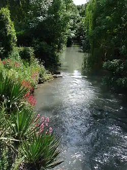 The Suippe at Pontfaverger-Moronvilliers | |
 | |
| Location | |
| Country | France |
| Physical characteristics | |
| Source | |
| • location | In Somme-Suippe |
| • coordinates | 49°06′51″N 04°34′53″E / 49.11417°N 4.58139°E |
| • elevation | 135 m (443 ft) |
| Mouth | |
• location | Aisne |
• coordinates | 49°25′29″N 03°56′58″E / 49.42472°N 3.94944°E |
• elevation | 51 m (167 ft) |
| Length | 81.7 km (50.8 mi) |
| Basin size | 802 km2 (310 sq mi) |
| Discharge | |
| • average | 4.34 m3/s (153 cu ft/s) |
| Basin features | |
| Progression | Aisne→ Oise→ Seine→ English Channel |
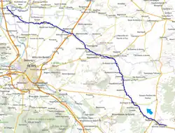
The Suippe (French pronunciation: [sɥip]) is an 81.7 km (50.8 mi) long river in the Marne and Aisne departments of north-eastern France.[1] Its source is at Somme-Suippe. It flows generally northwest. It is a left tributary of the Aisne, into which it flows at Condé-sur-Suippe.
Departments and communes it runs through
(ordered from source to mouth)
- Marne: Somme-Suippe, Suippes, Jonchery-sur-Suippe, Saint-Hilaire-le-Grand, Aubérive, Vaudesincourt, Dontrien, Saint-Martin-l'Heureux, Saint-Hilaire-le-Petit, Bétheniville, Pontfaverger-Moronvilliers, Selles, Saint-Masmes, Heutrégiville, Warmeriville, Isles-sur-Suippe, Bazancourt, Boult-sur-Suippe, Saint-Étienne-sur-Suippe, Bourgogne, Auménancourt.
- Aisne: Orainville, Bertricourt, Variscourt, Aguilcourt, Condé-sur-Suippe.
References
Wikimedia Commons has media related to Suippe.