Sunkar
| Sunkar | |
|---|---|
| Сұңқар | |
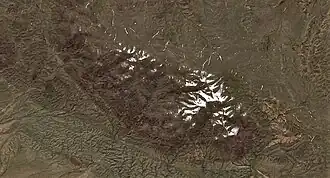 Sentinel-2 image centered on the Khantau Massif | |
| Highest point | |
| Elevation | 1,052 m (3,451 ft)[1] |
| Coordinates | 44°13′01″N 73°59′34″E / 44.21694°N 73.99278°E[1][2] |
| Geography | |
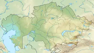 Sunkar Location in Kazakhstan | |
| Country | Kazakhstan |
| Region | Jambyl Region |
| Parent range | Khantau; Aitau |
| Geology | |
| Rock age(s) | Devonian, Silurian |
| Mountain type | Granite |
| Climbing | |
| Easiest route | From Khantau |
Sunkar (Kazakh: Сұңқар) is a mountain in Moiynkum District, Jambyl Region, Kazakhstan.
Geography
Sunkar rises in the northern flank of the Khantau massif, the northern section of the Aitau, part of the Chu-Ili Range. With an elevation 1,052 metres (3,451 ft), it is the highest summit of the range.[3][1][2]
See also
References
- ^ a b c "L-43 Chart (in Russian)". Retrieved 26 December 2023.
- ^ a b Google Earth
- ^ Kazakhstan National Encyclopedia / Ch. ed. B.O. Jakyp. — Almaty: « Kazakh encyclopedia» ZhSS, 2011. ISBN 9965-893-64-0 (T.Z.), ISBN 9965-893-19-5