Sweetwater, Idaho
Sweetwater, Idaho | |
|---|---|
 Location of Sweetwater in Nez Perce County, Idaho. | |
 Sweetwater, Idaho | |
| Coordinates: 46°22′21″N 116°47′35″W / 46.37250°N 116.79306°W | |
| Country | United States |
| State | Idaho |
| County | Nez Perce |
| Area | |
• Total | 1.191 sq mi (3.08 km2) |
| • Land | 1.191 sq mi (3.08 km2) |
| • Water | 0 sq mi (0 km2) |
| Elevation | 1,096 ft (334 m) |
| Population | |
• Total | 143 |
| • Density | 120/sq mi (46/km2) |
| Time zone | UTC-8 (Pacific (PST)) |
| • Summer (DST) | UTC-7 (PDT) |
| Area codes | 208, 986 |
| GNIS feature ID | 398208[2] |
Sweetwater is a census-designated place (CDP) in northern Nez Perce County, Idaho, United States. Its population was 143 as of the 2010 census.[1]
Description
The CDP is located along Lapwai Creek and U.S. Route 95 in the Lapwai Valley, about 2.5 miles (4.0 km) south of Lapwai.
Demographics
| Census | Pop. | Note | %± |
|---|---|---|---|
| 2010 | 143 | — | |
| U.S. Decennial Census[3] | |||
See also
References
- ^ a b "U.S. Census website". U.S. Census Bureau. Retrieved March 23, 2011.
- ^ U.S. Geological Survey Geographic Names Information System: Sweetwater
- ^ "Census of Population and Housing". Census.gov. Retrieved June 4, 2016.
External links
![]() Media related to Sweetwater, Idaho at Wikimedia Commons
Media related to Sweetwater, Idaho at Wikimedia Commons
Municipalities and communities of Nez Perce County, Idaho, United States | ||
|---|---|---|
| Cities | 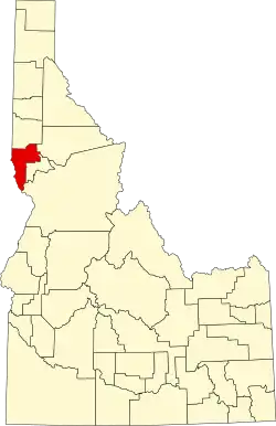 | |
| CDP | ||
| Unincorporated communities | ||
| Indian reservation | ||
| Footnotes | ‡This populated place also has portions in an adjacent county or counties | |