Törtel
Törtel | |
|---|---|
 | |
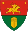 Coat of arms | |
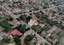
 Törtel Location of Törtel in Hungary | |
| Coordinates: 47°7′17.33″N 19°56′23.03″E / 47.1214806°N 19.9397306°E | |
| Country | Hungary |
| Region | Central Hungary |
| County | Pest |
| Subregion | Ceglédi |
| Rank | Village |
| Area | |
• Total | 84.16 km2 (32.49 sq mi) |
| Population (1 January 2008)[2] | |
• Total | 4,436 |
| • Density | 53/km2 (140/sq mi) |
| Time zone | UTC+1 (CET) |
| • Summer (DST) | UTC+2 (CEST) |
| Postal code | 2747 |
| Area code | +36 53 |
| KSH code | 22008[1] |
| Website | www.tortel.hu |
Törtel is a village in Pest county, Hungary.
References
- ^ a b Törtel at the Hungarian Central Statistical Office (Hungarian).
- ^ Törtel at the Hungarian Central Statistical Office (Hungarian). 1 January 2008
47°07′N 19°56′E / 47.117°N 19.933°E