Třebelovice
Třebelovice | |
|---|---|
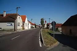 Centre of Třebelovice | |
 Flag  Coat of arms | |
 Třebelovice Location in the Czech Republic | |
| Coordinates: 49°1′20″N 15°39′58″E / 49.02222°N 15.66611°E | |
| Country | |
| Region | Vysočina |
| District | Třebíč |
| First mentioned | 1365 |
| Area | |
• Total | 11.44 km2 (4.42 sq mi) |
| Elevation | 468 m (1,535 ft) |
| Population (2025-01-01)[1] | |
• Total | 424 |
| • Density | 37/km2 (96/sq mi) |
| Time zone | UTC+1 (CET) |
| • Summer (DST) | UTC+2 (CEST) |
| Postal code | 675 32 |
| Website | www |
Třebelovice is a municipality and village in Třebíč District in the Vysočina Region of the Czech Republic. It has about 400 inhabitants.
Třebelovice lies approximately 27 kilometres (17 mi) south-west of Třebíč, 42 km (26 mi) south of Jihlava, and 149 km (93 mi) south-east of Prague.
History
The first written mention of Třebelovice is from 1365.[2]
Demographics
| Year | Pop. | ±% |
|---|---|---|
| 1869 | 608 | — |
| 1880 | 622 | +2.3% |
| 1890 | 643 | +3.4% |
| 1900 | 686 | +6.7% |
| 1910 | 718 | +4.7% |
| 1921 | 668 | −7.0% |
| 1930 | 609 | −8.8% |
| 1950 | 538 | −11.7% |
| 1961 | 531 | −1.3% |
| 1970 | 516 | −2.8% |
| 1980 | 518 | +0.4% |
| 1991 | 465 | −10.2% |
| 2001 | 467 | +0.4% |
| 2011 | 417 | −10.7% |
| 2021 | 394 | −5.5% |
| Source: Censuses[3][4] | ||
References
- ^ "Population of Municipalities – 1 January 2025". Czech Statistical Office. 2025-05-16.
- ^ "Historie obce" (in Czech). Obec Třebelovice. Retrieved 2022-04-28.
- ^ "Historický lexikon obcí České republiky 1869–2011" (in Czech). Czech Statistical Office. 2015-12-21.
- ^ "Population Census 2021: Population by sex". Public Database. Czech Statistical Office. 2021-03-27.
External links
Wikimedia Commons has media related to Třebelovice.