Tada-U Township
Tada-U Township
တံတားဦးမြို့နယ် | |
|---|---|
 | |
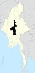
 Location (red) in Tada-U District | |
| Coordinates: 21°49′08″N 95°58′25″E / 21.81889°N 95.97361°E | |
| Country | |
| Region | |
| District | Tada-U District |
| Capital | Tada-U |
| Government | |
| • Type | Township Municipal |
| • MP | Thiha Aung |
| Area | |
• Total | 363.99 sq mi (942.7 km2) |
| Elevation | 200 ft (60 m) |
| Population (2023)[1] | |
• Total | 152,077 |
| • Density | 420/sq mi (160/km2) |
| Time zone | UTC+6:30 (MMT) |
Tada-U Township (Burmese: တံတားဦးမြို့နယ်) is a township of Tada-U District in central Mandalay Region of Myanmar. The ruins of the ancient city of Inwa is located in the townships' northeastern corner.[1]
Tada-U Township has one town, the principal town of Tada-U, which is sub-divided into 3 wards; while Tada-U Township's rural area is sub-divided into 61 village-tracts, which are further sub-divided into 165 villages.[1]
Village tracts
- Gwaykone
- Hta Naung Kaing
- Zee Kang
- Thabyegan
- Taungbyone
- Kangyi
- Thaman
- Thedaw
- Gaungkwe
- Myaengu
- Chaungkwa
- Myinthe
- Pyukan
- Hantharwaddy
- Zaygyo
- Zaga-in
- Zaga-te
- Zaba twin
- Aung Thar
- Myinsaing
References
- ^ a b c General Administration Department (March 2023). Tada U Myone Daethasaingyarachatlatmya အောင်လံမြို့နယ် ဒေသဆိုင်ရာအချက်လက်များ [Tada U Township Regional Information] (PDF) (Report). Retrieved 15 April 2025.