Tecolote, New Mexico
Tecolote, New Mexico | |
|---|---|
 Tecolote | |
| Coordinates: 35°27′38″N 105°17′03″W / 35.46056°N 105.28417°W | |
| Country | United States |
| State | New Mexico |
| County | San Miguel |
| Area | |
• Total | 5.63 sq mi (14.57 km2) |
| • Land | 5.63 sq mi (14.57 km2) |
| • Water | 0.00 sq mi (0.00 km2) |
| Elevation | 6,316 ft (1,925 m) |
| Population | |
• Total | 234 |
| • Density | 41.60/sq mi (16.06/km2) |
| Time zone | UTC-7 (Mountain (MST)) |
| • Summer (DST) | UTC-6 (MDT) |
| Area code | 505 |
| GNIS feature ID | 2584222[2] |
Tecolote is an unincorporated community and census-designated place in San Miguel County, New Mexico, United States. Its population was 298 as of the 2010 census.[4] The community is located along Interstate 25 at Exit 335.
Geography
According to the U.S. Census Bureau, the community has an area of 5.625 square miles (14.57 km2), all land.[4]
Demographics
| Census | Pop. | Note | %± |
|---|---|---|---|
| 2020 | 234 | — | |
| U.S. Decennial Census[5][3] | |||
Education
It is in the West Las Vegas Schools school district.[6] West Las Vegas High School is the area high school.
References
- ^ "ArcGIS REST Services Directory". United States Census Bureau. Retrieved October 12, 2022.
- ^ a b U.S. Geological Survey Geographic Names Information System: Tecolote, New Mexico
- ^ a b "Census Population API". United States Census Bureau. Retrieved October 12, 2022.
- ^ a b "2010 Census Gazetteer Files - Places: New Mexico". U.S. Census Bureau. Retrieved December 31, 2016.
- ^ "Census of Population and Housing". Census.gov. Retrieved June 4, 2016.
- ^ "2020 CENSUS - SCHOOL DISTRICT REFERENCE MAP: San Miguel County, NM" (PDF). U.S. Census Bureau. Retrieved July 12, 2022.
Municipalities and communities of San Miguel County, New Mexico, United States | ||
|---|---|---|
| City | 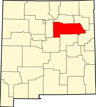 | |
| Villages | ||
| CDPs | ||
| Other communities | ||
| Ghost towns | ||
| Footnotes | ‡This populated place also has portions in an adjacent county or counties | |