Tereshka
| Bolshaya Tereshka River | |
|---|---|
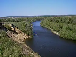 Tereshka in the Podgorny District. | |
| Location | |
| Country | Russia |
| Physical characteristics | |
| Source | |
| • location | Ulyanovsk Oblast |
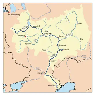
| Mouth | Volga |
• location | Volgograd Reservoir near Marks |
• coordinates | 51°49′1″N 46°32′33″E / 51.81694°N 46.54250°E |
| Length | 273 km (170 mi) |
| Basin size | 9,680 km2 (3,740 sq mi) |
| Discharge | |
| • average | 17.5 m3/s (620 cu ft/s) recorded 46 km (29 mi) from mouth |
| Basin features | |
| Progression | Volga→ Caspian Sea |
The Bolshaya Tereshka (Russian: Большая Терешка) or simply Tereshka is a river in the Ulyanovsk and Saratov oblasts of the Russian Federation, a right tributary of the Volga. The Tereshka is 273 kilometres (170 mi) long, and its watershed covers 9,680 square kilometres (3,740 sq mi).[1] It begins in the Privolzhskaya Hills and flows to the Volgograd Reservoir. Ice on the Tereshka forms in November or December and thaws in March or April.
References
- ^ «Река Терешка (Большая Терешка)», Russian State Water Registry
| Tributaries |
|  |
|---|---|---|
| Reservoirs | ||
| Hydroelectric stations | ||
| Canals | ||
| Cities | ||