Terre Haute, Iowa
Terre Haute, Iowa | |
|---|---|
 Terre Haute, Iowa | |
| Coordinates: 40°41′00″N 93°52′00″W / 40.68333°N 93.86667°W | |
| Country | United States |
| State | Iowa |
| County | Decatur |
| Elevation | 928 ft (283 m) |
| Time zone | UTC-6 (Central (CST)) |
| • Summer (DST) | UTC-5 (CDT) |
| Area code | 641 |
| GNIS feature ID | 462197[1] |
Terre Haute is an unincorporated community in Burrell Township, Decatur County, Iowa, United States.[1] Terre Haute is located along County Highway R30, 5.5 miles (8.9 km) northeast of Lamoni.[2]
References
- ^ a b "Terre Haute". Geographic Names Information System. United States Geological Survey, United States Department of the Interior.
- ^ "Decatur County, Iowa Highway and Transportation Map" (PDF). Iowa Department of Transportation. January 1, 2017. Retrieved July 21, 2018.
Municipalities and communities of Decatur County, Iowa, United States | ||
|---|---|---|
| Cities | 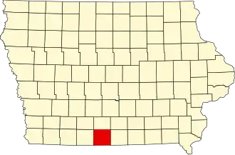 | |
| Townships | ||
| Unincorporated communities | ||