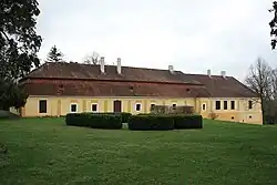
Tesáre
Tesáre
Nyitrateszér | |
|---|---|
 | |
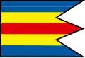 Flag | |
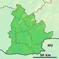 Tesáre Location of Tesáre in the Nitra Region  Tesáre Location of Tesáre in Slovakia | |
| Coordinates: 48°36′N 18°05′E / 48.60°N 18.08°E | |
| Country | |
| Region | |
| District | Topoľčany District |
| First mentioned | 1390 |
| Area | |
• Total | 13.54 km2 (5.23 sq mi) |
| Elevation | 207 m (679 ft) |
| Population (2021)[3] | |
• Total | 700 |
| Time zone | UTC+1 (CET) |
| • Summer (DST) | UTC+2 (CEST) |
| Postal code | 956 21[2] |
| Area code | +421 38[2] |
| Car plate | TO |
| Website | www |
Tesáre (Hungarian: Nyitrateszér) is municipality in the Topoľčany District of the Nitra Region, Slovakia.[4] In 2011 it had 712 inhabitants.[5]
References
- ^ "Hustota obyvateľstva - obce [om7014rr_ukaz: Rozloha (Štvorcový meter)]". www.statistics.sk (in Slovak). Statistical Office of the Slovak Republic. 2022-03-31. Retrieved 2022-03-31.
- ^ a b c "Základná charakteristika". www.statistics.sk (in Slovak). Statistical Office of the Slovak Republic. 2015-04-17. Retrieved 2022-03-31.
- ^ "Počet obyvateľov podľa pohlavia - obce (ročne)". www.statistics.sk (in Slovak). Statistical Office of the Slovak Republic. 2022-03-31. Retrieved 2022-03-31.
- ^ "Tesáre - Okres Topoľčany - E-OBCE.sk". en.e-obce.sk. Retrieved 2016-12-05.
- ^ Archived copy Archived 2013-10-12 at the Wayback Machine
External links