Thaya, Austria
Thaya | |
|---|---|
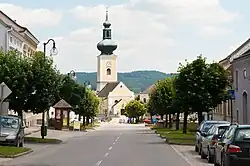 Church of Saints Peter and Paul | |
 Coat of arms | |
 Thaya Location within Austria | |
| Coordinates: 48°51′00″N 15°17′00″E / 48.85000°N 15.28333°E | |
| Country | Austria |
| State | Lower Austria |
| District | Waidhofen an der Thaya |
| Government | |
| • Mayor | Eduard Köck (ÖVP) |
| Area | |
• Total | 43.33 km2 (16.73 sq mi) |
| Elevation | 484 m (1,588 ft) |
| Population (2018-01-01)[2] | |
• Total | 1,380 |
| • Density | 32/km2 (82/sq mi) |
| Time zone | UTC+1 (CET) |
| • Summer (DST) | UTC+2 (CEST) |
| Postal code | 3842 |
| Area code | 02842 |
| Vehicle registration | WT |
| Website | www.thaya.at |
Thaya is a municipality in the district of Waidhofen an der Thaya in the Austrian state of Lower Austria.
Population
| Year | Pop. | ±% |
|---|---|---|
| 1971 | 1,755 | — |
| 1981 | 1,548 | −11.8% |
| 1991 | 1,424 | −8.0% |
| 2001 | 1,468 | +3.1% |
| 2013 | 1,724 | +17.4% |
References
- ^ "Dauersiedlungsraum der Gemeinden Politischen Bezirke und Bundesländer - Gebietsstand 1.1.2018". Statistics Austria. Retrieved 10 March 2019.
- ^ "Einwohnerzahl 1.1.2018 nach Gemeinden mit Status, Gebietsstand 1.1.2018". Statistics Austria. Retrieved 9 March 2019.
External links
Wikimedia Commons has media related to Thaya (Municipality).