Theba, Alabama
Theba, Alabama | |
|---|---|
 Theba, Alabama  Theba, Alabama | |
| Coordinates: 31°33′21″N 86°18′13″W / 31.55583°N 86.30361°W | |
| Country | United States |
| State | Alabama |
| County | Crenshaw |
| Elevation | 289 ft (88 m) |
| Time zone | UTC-6 (Central (CST)) |
| • Summer (DST) | UTC-5 (CDT) |
| Area code | 334 |
| GNIS feature ID | 155271[1] |
Theba is an unincorporated community in Crenshaw County, Alabama, United States. Theba is located on U.S. Route 29, 3.3 miles (5.3 km) southwest of Brantley.[2]
References
- ^ "Theba". Geographic Names Information System. United States Geological Survey, United States Department of the Interior.
- ^ General Highway Map: Crenshaw County, Alabama (PDF) (Map). Alabama Department of Transportation. 2007. Archived from the original (PDF) on February 21, 2014. Retrieved February 14, 2013.
Municipalities and communities of Crenshaw County, Alabama, United States | ||
|---|---|---|
| Cities | 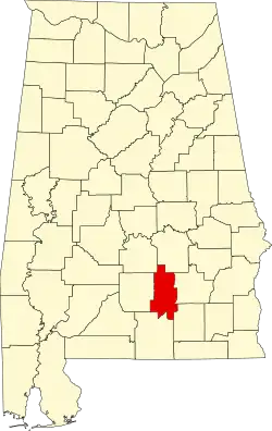 | |
| Towns | ||
| Unincorporated communities | ||
| Footnotes | ‡This populated place also has portions in an adjacent county or counties | |