Thel, Rhône
Thel | |
|---|---|
Part of Cours | |
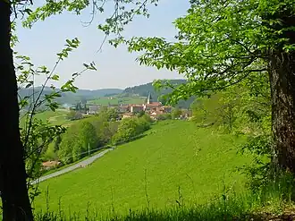 The landscape of Thel | |
.svg.png) Coat of arms | |
Location of Thel | |
 Thel  Thel | |
| Coordinates: 46°06′59″N 4°22′40″E / 46.1164°N 4.3778°E | |
| Country | France |
| Region | Auvergne-Rhône-Alpes |
| Department | Rhône |
| Arrondissement | Villefranche-sur-Saône |
| Canton | Thizy-les-Bourgs |
| Commune | Cours |
Area 1 | 10.27 km2 (3.97 sq mi) |
| Population (2022)[1] | 325 |
| • Density | 32/km2 (82/sq mi) |
| Time zone | UTC+01:00 (CET) |
| • Summer (DST) | UTC+02:00 (CEST) |
| Postal code | 69470 |
| Elevation | 547–905 m (1,795–2,969 ft) (avg. 780 m or 2,560 ft) |
| 1 French Land Register data, which excludes lakes, ponds, glaciers > 1 km2 (0.386 sq mi or 247 acres) and river estuaries. | |
Thel (French pronunciation: [tɛl]) is a former commune in the Rhône department in eastern France.
History
On 1 January 2016, Cours-la-Ville, Pont-Trambouze and Thel merged becoming one commune called Cours.
See also
References
- ^ "Populations de référence 2022" [Reference populations 2022] (PDF) (in French). INSEE. December 2024.
Wikimedia Commons has media related to Thel.