Tracys Landing, Maryland
Tracys Landing, Maryland | |
|---|---|
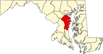
 Tracys Landing, Maryland Location within the state of Maryland  Tracys Landing, Maryland Tracys Landing, Maryland (the United States) | |
| Coordinates: 38°46′48″N 76°35′45″W / 38.78000°N 76.59583°W | |
| Country | |
| State | |
| County | |
| Elevation | 50 ft (20 m) |
| Time zone | UTC-5 (Eastern (EST)) |
| • Summer (DST) | UTC-4 (EDT) |
| ZIP code | 20779[1] |
| Area codes | 410,443 and 667 |
Tracys Landing is an unincorporated community in Anne Arundel County, Maryland, United States.[2] Tracy's Landing Tobacco House No. 2 was listed on the National Register of Historic Places in 1982.[3] The St. James Church was listed on the National Register of Historic Places in 1972.[3]
Geography
Tracys Landing is adjacent to the waterfront town of Deale.
References
- ^ "Tracys Landing ZIP Code". zipdatamaps.com. 2022. Retrieved November 18, 2022.
- ^ U.S. Geological Survey Geographic Names Information System: Tracys Landing, Maryland
- ^ a b "National Register Information System". National Register of Historic Places. National Park Service. April 15, 2008.
Wikimedia Commons has media related to Tracys Landing, Maryland.