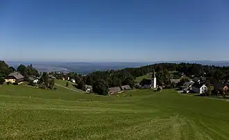
Trahütten
Trahütten | |
|---|---|
 Trahütten | |
 Coat of arms | |
 Trahütten Location within Austria | |
| Coordinates: 46°49′23″N 15°09′08″E / 46.82306°N 15.15222°E | |
| Country | Austria |
| State | Styria |
| District | Deutschlandsberg |
| Area | |
• Total | 28.23 km2 (10.90 sq mi) |
| Elevation | 994 m (3,261 ft) |
| Population (1 January 2016)[1] | |
• Total | 396 |
| • Density | 14/km2 (36/sq mi) |
| Time zone | UTC+1 (CET) |
| • Summer (DST) | UTC+2 (CEST) |
| Postal code | 8530 |
| Area code | 03461 |
| Vehicle registration | DL |
| Website | www.trahuetten.at |
Trahütten is a former municipality in the district of Deutschlandsberg in Austrian state of Styria. Since the 2015 Styria municipal structural reform, it is part of the municipality Deutschlandsberg.[2]
Population
| Year | Pop. | ±% |
|---|---|---|
| 1869 | 666 | — |
| 1880 | 637 | −4.4% |
| 1890 | 609 | −4.4% |
| 1900 | 559 | −8.2% |
| 1910 | 531 | −5.0% |
| 1923 | 613 | +15.4% |
| 1934 | 604 | −1.5% |
| 1939 | 577 | −4.5% |
| 1951 | 559 | −3.1% |
| 1961 | 482 | −13.8% |
| 1971 | 439 | −8.9% |
| 1981 | 402 | −8.4% |
| 1991 | 391 | −2.7% |
| 2001 | 412 | +5.4% |
| 2011 | 402 | −2.4% |
References