Troianata
Troianata
Τρωιανάτα | |
|---|---|
 | |
 Troianata | |
| Coordinates: 38°9.5′N 20°33.4′E / 38.1583°N 20.5567°E | |
| Country | Greece |
| Administrative region | Ionian Islands |
| Regional unit | Kefalonia |
| Municipality | Argostoli |
| Municipal unit | Argostoli |
| Population (2021)[1] | |
• Community | 248 |
| Time zone | UTC+2 (EET) |
| • Summer (DST) | UTC+3 (EEST) |
| Vehicle registration | KE |
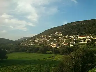
Troianata (Greek: Τρωιανάτα) is a village and a community in the municipal unit of Argostoli, on the island of Cephalonia, Greece. The community consists of the villages Troianata, Demoutsantata and Mitakata. Troianata is situated on a hillside, at about 300 m elevation. It is 3 km north of Peratata, 3 km southwest of Valsamata and 6 km southeast of Argostoli. Troianata suffered great damage from the 1953 Ionian earthquake.
Historical population
| Year | Population community |
|---|---|
| 1981 | 168 |
| 1991 | 130 |
| 2001 | 175 |
| 2011 | 223 |
| 2021 | 248 |
See also
References
- ^ "Αποτελέσματα Απογραφής Πληθυσμού - Κατοικιών 2021, Μόνιμος Πληθυσμός κατά οικισμό" [Results of the 2021 Population - Housing Census, Permanent population by settlement] (in Greek). Hellenic Statistical Authority. 29 March 2024.