Tuzly Lagoons
| Tuzly Lagoons | |
|---|---|
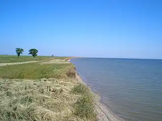 Northern coast of Alibey Lagoon, one of the 3 main lagoons in the group. | |
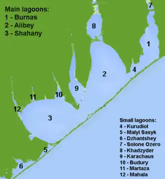 The schematic map of the Tuzly Lagoons | |
 Tuzly Lagoons | |
| Location | Black Sea |
| Coordinates | 45°47′N 30°00′E / 45.783°N 30.000°E |
| Ocean/sea sources | Atlantic Ocean |
| Basin countries | Ukraine |
| Max. length | 29 km (18 mi) |
| Surface area | 206 km2 (80 sq mi) |
| Average depth | 1.0–1.3 m (3.3–4.3 ft) |
| Max. depth | 2.5 m (8.2 ft) |
| Salinity | 18-40 ‰ |
| Official name | Shagany-Alibei-Burnas Lakes System |
| Designated | 23 November 1995 |
| Reference no. | 763[1] |
Tuzly Lagoons (Ukrainian: Тузловські лимани, Romanian: Limanele Tuzlei) are a group of marine lagoons (limans) in southern Bessarabia (Budjak), Ukraine. The lagoons are part of the Tuzly Lagoons National Nature Park, proclaimed on January 1, 2010.[2] The name of the lagoons originates from the Turkish: Tuzlu, which means salty.
The group includes three main lagoons: Shahany, Alibey, and Burnas, and also smaller lagoons: Solone Ozero, Khadzhyder, Karachaus, Budury, Kurudiol, Martaza, Mahala, Malyi Sasyk, and Dzhantshey.[3]
The total area of the lagoons is 206 km2, depth 1.6–2.5 m, averaging 1.0–1.3 m. The lagoons are separated from the Black Sea by a 29-km long sandbar, which is 60–400 m wide and 1–3 m high.[4]
Notes and references
- ^ "Shagany-Alibei-Burnas Lakes System". Ramsar Sites Information Service. Retrieved 25 April 2018.
- ^ "President of Ukraine's decree № 1/2010 for the creation of the Tuzly Limans national nature park" Archived 2011-08-10 at the Wayback Machine (in Ukrainian)
- ^ "Pearls of the Black Sea" (in Ukrainian)
- ^ "Starushenko L.I., Bushuyev S.G. (2001) Prichernomorskiye limany Odeschiny i ih rybohoziaystvennoye znacheniye". Astroprint, Odesa, 151 pp. (in Russian)