Tyrnau
Tyrnau | |
|---|---|
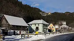 View of Tyrnau | |
 Coat of arms | |
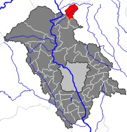 Location within Weiz district | |
 Tyrnau Location within Austria | |
| Coordinates: 47°18′43″N 15°24′54″E / 47.31194°N 15.41500°E | |
| Country | Austria |
| State | Styria |
| District | Weiz |
| Area | |
• Total | 19.97 km2 (7.71 sq mi) |
| Elevation | 666 m (2,185 ft) |
| Population (1 January 2016)[1] | |
• Total | 158 |
| • Density | 7.9/km2 (20/sq mi) |
| Time zone | UTC+1 (CET) |
| • Summer (DST) | UTC+2 (CEST) |
| Postal code | 8130 |
| Area code | 03179 |
| Vehicle registration | GU |
| Website | www.tyrnau.steiermark.at |
Tyrnau (German pronunciation: [ˈtʏʁnaʊ̯] ⓘ) is a former municipality in the district of Graz-Umgebung in the Austrian state of Styria. Since the 2015 Styria municipal structural reform, it is part of the municipality Fladnitz an der Teichalm, in the Weiz District.[2]
Population
| Year | Pop. | ±% |
|---|---|---|
| 1869 | 413 | — |
| 1880 | 414 | +0.2% |
| 1890 | 353 | −14.7% |
| 1900 | 348 | −1.4% |
| 1910 | 288 | −17.2% |
| 1923 | 294 | +2.1% |
| 1934 | 321 | +9.2% |
| 1939 | 317 | −1.2% |
| 1951 | 284 | −10.4% |
| 1961 | 250 | −12.0% |
| 1971 | 191 | −23.6% |
| 1981 | 159 | −16.8% |
| 1991 | 166 | +4.4% |
| 2001 | 151 | −9.0% |
References