Upper Exeter, Pennsylvania
Upper Exeter, Pennsylvania | |
|---|---|
 Upper Exeter Location within the state of Pennsylvania  Upper Exeter Upper Exeter (the United States) | |
| Coordinates: 41°24′25″N 75°50′15″W / 41.40694°N 75.83750°W | |
| Country | United States |
| State | Pennsylvania |
| County | Luzerne |
| Township | Exeter |
| Area | |
• Total | 2.0 sq mi (5.3 km2) |
| • Land | 2.0 sq mi (5.1 km2) |
| • Water | 0.08 sq mi (0.2 km2) |
| Population (2010) | |
• Total | 707 |
| • Density | 350/sq mi (130/km2) |
| Time zone | UTC-5 (Eastern (EST)) |
| • Summer (DST) | UTC-4 (EDT) |
| Area code | 570 |
Upper Exeter is a census-designated place (CDP) in Exeter Township, Luzerne County, Pennsylvania, United States. The population was 707 at the 2010 census.[1]
Geography
Upper Exeter is located at 41°24′25″N 75°50′15″W / 41.40694°N 75.83750°W,[2] along Pennsylvania Route 92 in the northern part of Exeter Township. It is situated on the west bank of the Susquehanna River, approximately 6 miles (10 km) north of Pittston.
According to the United States Census Bureau, the CDP has a total area of 2.0 square miles (5.3 km2), of which 2.0 square miles (5.1 km2) is land and 0.077 square miles (0.2 km2), or 4.46%, is water.[3]
Education
It is in the Wyoming Area School District.[4]
References
- ^ "Profile of General Population and Housing Characteristics: 2010 Demographic Profile Data (DP-1): Upper Exeter CDP, Pennsylvania". United States Census Bureau. Retrieved April 30, 2012.
- ^ "US Gazetteer files: 2010, 2000, and 1990". United States Census Bureau. February 12, 2011. Retrieved April 23, 2011.
- ^ "Geographic Identifiers: 2010 Demographic Profile Data (G001): Upper Exeter CDP, Pennsylvania". United States Census Bureau. Retrieved April 30, 2012.
- ^ "2020 CENSUS - SCHOOL DISTRICT REFERENCE MAP: Luzerne County, PA" (PDF). U.S. Census Bureau. Retrieved December 13, 2024. - Text list
Municipalities and communities of Luzerne County, Pennsylvania, United States | ||
|---|---|---|
| Cities | 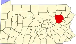 | |
| Boroughs |
| |
| Townships | ||
| CDPs | ||
| Unincorporated communities |
| |
| Footnotes | ‡This populated place also has portions in an adjacent county or counties | |