Utley, Texas
Utley, Texas | |
|---|---|
 Utley  Utley | |
| Coordinates: 30°10′55″N 97°25′15″W / 30.18194°N 97.42083°W | |
| Country | United States |
| State | Texas |
| County | Bastrop |
| Elevation | 417 ft (127 m) |
| Time zone | UTC-6 (Central (CST)) |
| • Summer (DST) | UTC-5 (CDT) |
| Area codes | 512 & 737 |
| GNIS feature ID | 1379199[1] |
Utley (/ˈjuːtli/ YOOT-lee) is an unincorporated community in Bastrop County, Texas, United States.[1] According to the Handbook of Texas, the community had a population of 50 in 2000. It is located within the Greater Austin metropolitan area.
History
Today, the community is now a put-in-point for canoeists on the Colorado River. The Wilbarger family also named a nearby creek.[2]
Geography
Utley is located along Farm to Market Road 969, 7 mi (11 km) northwest of Bastrop, 26 mi (42 km) southeast of Austin, and 13 mi (21 km) south of Elgin in western Bastrop County.[2]
Education
Utley had a school for Hispanic students in the 1930s.[3] The west half of Utley today is served by the Elgin Independent School District and the east half by the Bastrop Independent School District.
References
- ^ a b c U.S. Geological Survey Geographic Names Information System: Utley, Texas
- ^ a b "Utley, Texas". Texas Escapes Online Magazine. Retrieved June 20, 2022.
- ^ Mitchell Marks, Paula. "Utley, TX". tshaonline.org. Retrieved June 20, 2022.
Municipalities and communities of Bastrop County, Texas, United States | ||
|---|---|---|
| Cities | 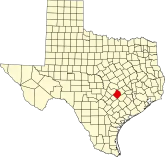 | |
| CDPs | ||
| Other communities | ||
| Ghost towns | ||
| Footnotes | ‡This populated place also has portions in an adjacent county or counties | |