Võhandu
| Võhandu | |
|---|---|
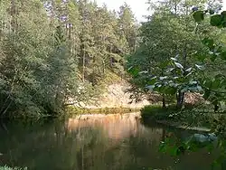 The Võhandu at Viira Wall | |
| Location | |
| Country | Estonia |
| Physical characteristics | |
| Source | |
| • location | near Saverna[1] |
| • coordinates | 58°03′42″N 26°42′58″E / 58.06167°N 26.71611°E |
| • elevation | 132 m (433 ft) |
| Mouth | |
• location | Lake Lämmi[1] |
• coordinates | 58°06′04″N 27°33′16″E / 58.10111°N 27.55444°E |
• elevation | 30 m (98 ft) |
| Length | 166 km (103 mi) |
| Basin size | 1,426 km2 (551 sq mi) |
| Discharge | |
| • average | 5.5–6.0 m3/s (190–210 cu ft/s) |
| Basin features | |
| Progression | Lake Peipus→ Narva→ Gulf of Finland |
The Võhandu (Estonian: Võhandu) is the longest river entirely in Estonia.[1] It is 166 km (103 mi) long and drains 1,426 km2 (551 sq mi). [2] The river begins near the village of Saverna in Põlva County and empties into Lake Lämmi, a part of Lake Peipus. [1]
In 1964, a protected area was founded in the Võhandu Valley. [3]
Wikimedia Commons has media related to Võhandu River.
References
- ^ a b c d "Võhandu jõgi - Eesti Entsüklopeedia". entsyklopeedia.ee. Retrieved 2 March 2024.
- ^ "Võhandu jõgi". Eesti looduse infosüsteemi (in Estonian). Keskkonnaagentuur. Archived from the original on 20 June 2025. Retrieved 20 June 2025.
- ^ "Võhandu jõe ürgorg". Eesti looduse infosüsteemi (in Estonian). Keskkonnaagentuur. Retrieved 20 June 2025.