Virieu
Virieu | |
|---|---|
Part of Val-de-Virieu | |
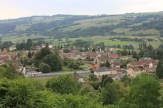 A general view of Virieu | |
 Coat of arms | |
Location of Virieu | |
 Virieu  Virieu | |
| Coordinates: 45°29′11″N 5°28′34″E / 45.4864°N 5.4761°E | |
| Country | France |
| Region | Auvergne-Rhône-Alpes |
| Department | Isère |
| Arrondissement | La Tour-du-Pin |
| Canton | Le Grand-Lemps |
| Commune | Val-de-Virieu |
Area 1 | 11.38 km2 (4.39 sq mi) |
| Population (2018)[1] | 1,092 |
| • Density | 96/km2 (250/sq mi) |
| Time zone | UTC+01:00 (CET) |
| • Summer (DST) | UTC+02:00 (CEST) |
| Postal code | 38730 |
| Elevation | 384–775 m (1,260–2,543 ft) |
| 1 French Land Register data, which excludes lakes, ponds, glaciers > 1 km2 (0.386 sq mi or 247 acres) and river estuaries. | |
Virieu (French pronunciation: [viʁjø]), also Virieu-sur-Bourbre (French pronunciation: [viʁjø syʁ buʁbʁ], literally Virieu on Bourbre), is a former commune in the Isère department in southeastern France. On 1 January 2019, it was merged into the new commune Val-de-Virieu.[2]
Geography
The small river Bourbre forms most of the commune's western border.
Population
|
|
See also
References
- ^ Téléchargement du fichier d'ensemble des populations légales en 2018, INSEE
- ^ Arrêté préfectoral 11 October 2018, p. 275 (in French)
External links
Wikimedia Commons has media related to Virieu.