Voinémont
Voinémont | |
|---|---|
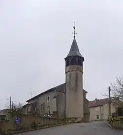 The church in Voinémont | |
 Coat of arms | |
Location of Voinémont | |
 Voinémont  Voinémont | |
| Coordinates: 48°31′19″N 6°09′49″E / 48.5219°N 6.1636°E | |
| Country | France |
| Region | Grand Est |
| Department | Meurthe-et-Moselle |
| Arrondissement | Nancy |
| Canton | Meine au Saintois |
| Intercommunality | Pays du Saintois |
| Government | |
| • Mayor (2020–2026) | Marie-France Siron[1] |
Area 1 | 4.11 km2 (1.59 sq mi) |
| Population (2022)[2] | 333 |
| • Density | 81/km2 (210/sq mi) |
| Time zone | UTC+01:00 (CET) |
| • Summer (DST) | UTC+02:00 (CEST) |
| INSEE/Postal code | 54591 /54134 |
| Elevation | 229–314 m (751–1,030 ft) (avg. 238 m or 781 ft) |
| 1 French Land Register data, which excludes lakes, ponds, glaciers > 1 km2 (0.386 sq mi or 247 acres) and river estuaries. | |
Voinémont (French pronunciation: [vwanemɔ̃]) is a commune in the Meurthe-et-Moselle department in north-eastern France.
Geography
The village lies in the north-western part of the commune, on the right bank of the river Madon, which forms all of the commune's southern and western borders.
See also
References
- ^ "Répertoire national des élus: les maires". data.gouv.fr, Plateforme ouverte des données publiques françaises (in French). 2 December 2020.
- ^ "Populations de référence 2022" (in French). The National Institute of Statistics and Economic Studies. 19 December 2024.
Wikimedia Commons has media related to Voinémont.