Vop (river)
| Vop | |
|---|---|
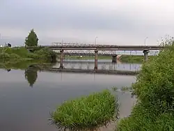 The Vop at Yartsevo | |
| Location | |
| Country | Russia |
| Physical characteristics | |
| Mouth | Dnieper |
• coordinates | 54°55′38″N 32°44′07″E / 54.92722°N 32.73528°E |
| Length | 158 km (98 mi) |
| Basin size | 3,300 km2 (1,300 sq mi) |
| Discharge | |
| • average | 22 m3/s (780 cu ft/s) |
| Basin features | |
| Progression | Dnieper→ Dnieper–Bug estuary→ Black Sea |
The Vop (Russian: Вопь) is a river in Smolensk Oblast, Russia. It is a right tributary of the Dnieper. It is 158 km long, with a drainage basin of 3300 km². The average discharge is 22 m³/s.[1]
The river was the site of intense combat operations in the Smolensk region in the period July–September, 1941 as part of Operation Barbarossa.
References