Vyšný Orlík
Vyšný Orlík | |
|---|---|
 | |
 Flag  Coat of arms | |
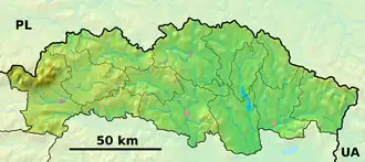 Vyšný Orlík Location of Vyšný Orlík in the Prešov Region  Vyšný Orlík Location of Vyšný Orlík in Slovakia | |
| Coordinates: 49°21′N 21°30′E / 49.35°N 21.50°E | |
| Country | |
| Region | |
| District | Svidník District |
| First mentioned | 1414 |
| Area | |
• Total | 14.78 km2 (5.71 sq mi) |
| Elevation | 264 m (866 ft) |
| Population (2021)[3] | |
• Total | 386 |
| Time zone | UTC+1 (CET) |
| • Summer (DST) | UTC+2 (CEST) |
| Postal code | 901 1[2] |
| Area code | +421 54[2] |
| Car plate | SK |
| Website | www |
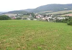
Vyšný Orlík is a village and municipality in Svidník District in the Prešov Region of north-eastern Slovakia.
History
The village was first mentioned in 1414 and had various names throughout history such as Felsoodor (1907-1913) and later, Vyšný Orlík. The Greek Catholic church of the Accession of the Lord was established in 1793 and this village is predominantly Carpatho-Rusyn Greek Catholic.
A more detailed history with photographs can be found at....
Vyšný Orlík - The Carpathian Connection
Geography
The municipality lies at an altitude of 283 metres and covers an area of 14.716 km2. It has a population of about 413 people.
References
- ^ "Hustota obyvateľstva - obce [om7014rr_ukaz: Rozloha (Štvorcový meter)]". www.statistics.sk (in Slovak). Statistical Office of the Slovak Republic. 2022-03-31. Retrieved 2022-03-31.
- ^ a b c "Základná charakteristika". www.statistics.sk (in Slovak). Statistical Office of the Slovak Republic. 2015-04-17. Retrieved 2022-03-31.
- ^ "Počet obyvateľov podľa pohlavia - obce (ročne)". www.statistics.sk (in Slovak). Statistical Office of the Slovak Republic. 2022-03-31. Retrieved 2022-03-31.
External links
 Media related to Vyšný Orlík at Wikimedia Commons
- Official website
