Vyazma (river)
| Vyazma | |
|---|---|
 | |
.png) | |
| Native name | Вязьма (Russian) |
| Location | |
| Country | Russia |
| Physical characteristics | |
| Mouth | Dnieper |
• coordinates | 55°28′24″N 33°33′31″E / 55.47333°N 33.55861°E |
| Length | 147 km (91 mi) |
| Basin size | 1,350 km2 (520 sq mi) |
| Basin features | |
| Progression | Dnieper→ Dnieper–Bug estuary→ Black Sea |
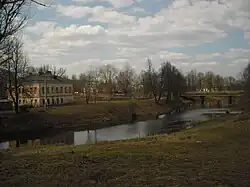
The Vyazma (Russian: Вязьма) is a river in Smolensk Oblast, Russia. It is a left tributary of the Dnieper. The length of the river is 147 kilometres (91 mi). The area of its basin is 1,350 square kilometres (520 sq mi).[1] In ancient times, the Vyazma River was a part of a route that connected the upper basins of the Volga, Oka, and Dnieper with the help of portages. The city of Vyazma is located on the Vyazma River.
References