Waikouaiti River
| Waikouaiti River | |
|---|---|
 | |
Route of the Waikouaiti River | |
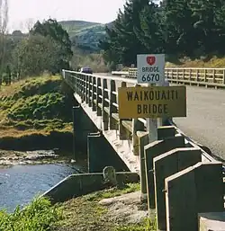
.png) Mouth of the Waikouaiti River  Waikouaiti River (South Island) | |
| Location | |
| Country | New Zealand |
| Physical characteristics | |
| Source | Macraes (North Branch) |
| • coordinates | 45°23′27″S 170°25′35″E / 45.3908°S 170.4263°E |
| 2nd source | The Silverpeaks (South Branch) |
| • coordinates | 45°44′53″S 170°27′42″E / 45.7481°S 170.4618°E |
| Mouth | |
• location | Pacific Ocean |
• coordinates | 45°38′24″S 170°39′42″E / 45.640088°S 170.661707°E |
| Basin features | |
| Progression | Waikouaiti River → Pacific Ocean |
| Tributaries | |
| • left | Murphys Creek (North Branch), Toll Bar Creek (South Branch), Sluice Box Creek (South Branch), Mount Misery Creek (South Branch) |
| • right | Back Creek (North Branch), Deep Creek (North Branch), Dip Creek (North Branch) |
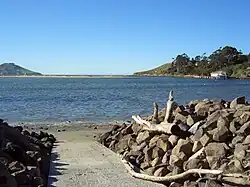
The Waikouaiti River is found to the north of Dunedin in Otago, New Zealand.[1] It flows to the Pacific Ocean at Karitane, close to the town of Waikouaiti.[2]
The Waikouaiti River is the largest river in East Otago.[3]
References
- ^ "Environmental monitoring data for Waikouaiti River". Land, Air, Water Aotearoa (LAWA). Retrieved 23 May 2021.
- ^ "Locals help restore the Waikouaiti River in Otago". The Tindall Foundation. 7 July 2015. Retrieved 23 May 2021.
- ^ "Waikouaiti River at Bucklands". Swim Guide. 2021. Retrieved 23 May 2021.