Wall Lane, Arizona
Wall Lane, Arizona | |
|---|---|
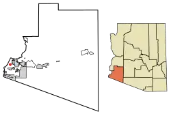 Location of Wall Lane in Yuma County, Arizona. | |
 Wall Lane | |
| Coordinates: 32°39′26″N 114°42′38″W / 32.65722°N 114.71056°W | |
| Country | United States |
| State | Arizona |
| County | Yuma |
| Area | |
• Total | 0.44 sq mi (1.13 km2) |
| • Land | 0.44 sq mi (1.13 km2) |
| • Water | 0.00 sq mi (0.00 km2) |
| Elevation | 112 ft (34 m) |
| Population (2020) | |
• Total | 262 |
| • Density | 599.54/sq mi (231.68/km2) |
| Time zone | UTC-7 (Mountain (MST)) |
| ZIP code | 85365[3] |
| Area code | 928 |
| GNIS feature ID | 2582895[2] |
Wall Lane is a census-designated place and colonia[4] in Yuma County, in the U.S. state of Arizona.[2] The population was 415 at the 2010 census.[5]
Geography
According to the U.S. Census Bureau, the community has an area of 0.436 square miles (1.13 km2), all land.[5]
Education
Wall Lane is served by the Crane Elementary School District and the Yuma Union High School District.[6]
Demographics
| Census | Pop. | Note | %± |
|---|---|---|---|
| 2020 | 262 | — | |
| U.S. Decennial Census[7] | |||
References
- ^ "2020 U.S. Gazetteer Files". United States Census Bureau. Retrieved October 29, 2021.
- ^ a b c U.S. Geological Survey Geographic Names Information System: Wall Lane, Arizona
- ^ "Wall Lane AZ ZIP Code". zipdatamaps.com. 2023. Retrieved May 3, 2023.
- ^ "State of ARIZONA –Department of Housing's - Designated Colonias" (PDF). August 28, 2023. Archived from the original (PDF) on March 24, 2024.
- ^ a b "2010 Census Gazetteer Files – Places: Arizona". U.S. Census Bureau. Retrieved February 26, 2017.
- ^ https://www.craneschools.org/apps/pages/index.jsp?uREC_ID=1924647&type=d&pREC_ID=2061454
- ^ "Census of Population and Housing". Census.gov. Retrieved June 4, 2016.
Municipalities and communities of Yuma County, Arizona, United States | ||
|---|---|---|
| Cities |  | |
| Town | ||
| CDPs | ||
| Populated places | ||
| Indian reservations | ||
| Ghost towns | ||
| Footnotes | ‡This populated place also has portions in an adjacent county or counties | |