Wallingford, Kentucky
Wallingford, Kentucky | |
|---|---|
 Wallingford  Wallingford | |
| Coordinates: 38°24′18″N 83°36′44″W / 38.40500°N 83.61222°W | |
| Country | United States |
| State | Kentucky |
| County | Fleming |
| Elevation | 794 ft (242 m) |
| Time zone | UTC-5 (Eastern (EST)) |
| • Summer (DST) | UTC-4 (EDT) |
| ZIP code | 41093 |
| Area code | 606 |
| GNIS feature ID | 506152[1] |
Wallingford is an unincorporated community in Fleming County, Kentucky, United States.[1] The community is located along Kentucky Route 559 6.7 miles (10.8 km) east of Flemingsburg. Wallingford has a post office with ZIP code 41093.[2][3]
References
- ^ a b "Wallingford". Geographic Names Information System. United States Geological Survey, United States Department of the Interior.
- ^ United States Postal Service. "USPS - Look Up a ZIP Code". Retrieved April 11, 2017.
- ^ "Postmaster Finder - Post Offices by ZIP Code". United States Postal Service. Archived from the original on October 17, 2020. Retrieved April 11, 2017.
Municipalities and communities of Fleming County, Kentucky, United States | ||
|---|---|---|
| Cities | 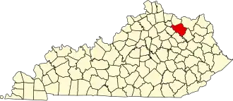 | |
| CDP | ||
| Other unincorporated communities | ||