Wansheng, Chongqing
Wansheng District
万盛区 | |
|---|---|
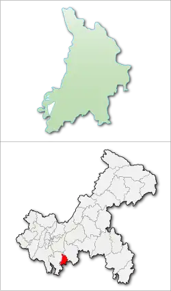 Wansheng District in Chongqing | |
| Country | People's Republic of China |
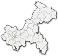
| Municipality | Chongqing |
| Area | |
| • Land | 566 km2 (219 sq mi) |
| Population (2007) | |
• Total | 270,000 |
| Time zone | UTC+8 (China Standard) |
Wansheng District (simplified Chinese: 万盛区; traditional Chinese: 萬盛區; pinyin: Wànshèng Qū) is a former district of Chongqing Municipality, China.
In October 2011, Wansheng was merged into the much poorer Qijiang County to form the new Qijiang District.[1][2]
Wansheng is a popular tourist destination in Chongqing, attracting tourists to natural attractions such as the Black Valley and Wansheng stone forest.[3] The stone forest of Wansheng is the second largest in China.[4] Before the development of tourism, Wansheng was a major coal producing area, with up to half of coal mined in Chongqing being mined in Wansheng.[5]
Climate
| Climate data for Wansheng, elevation 325 m (1,066 ft), (1991–2020 normals, extremes 1981–2010) | |||||||||||||
|---|---|---|---|---|---|---|---|---|---|---|---|---|---|
| Month | Jan | Feb | Mar | Apr | May | Jun | Jul | Aug | Sep | Oct | Nov | Dec | Year |
| Record high °C (°F) | 21.2 (70.2) |
26.6 (79.9) |
35.5 (95.9) |
36.9 (98.4) |
39.2 (102.6) |
40.4 (104.7) |
41.5 (106.7) |
44.3 (111.7) |
44.3 (111.7) |
37.3 (99.1) |
30.6 (87.1) |
22.9 (73.2) |
44.3 (111.7) |
| Mean daily maximum °C (°F) | 10.8 (51.4) |
14.2 (57.6) |
19.1 (66.4) |
24.2 (75.6) |
27.8 (82.0) |
30.0 (86.0) |
34.2 (93.6) |
33.9 (93.0) |
29.7 (85.5) |
22.7 (72.9) |
18.2 (64.8) |
12.2 (54.0) |
23.1 (73.6) |
| Daily mean °C (°F) | 7.6 (45.7) |
10.2 (50.4) |
14.0 (57.2) |
18.8 (65.8) |
22.2 (72.0) |
25.0 (77.0) |
28.3 (82.9) |
27.8 (82.0) |
24.2 (75.6) |
18.7 (65.7) |
14.2 (57.6) |
9.2 (48.6) |
18.3 (65.0) |
| Mean daily minimum °C (°F) | 5.7 (42.3) |
7.8 (46.0) |
10.8 (51.4) |
15.2 (59.4) |
18.5 (65.3) |
21.5 (70.7) |
24.2 (75.6) |
23.6 (74.5) |
20.5 (68.9) |
16.1 (61.0) |
11.8 (53.2) |
7.3 (45.1) |
15.3 (59.5) |
| Record low °C (°F) | −0.8 (30.6) |
0.0 (32.0) |
−0.7 (30.7) |
5.5 (41.9) |
9.6 (49.3) |
15.1 (59.2) |
17.1 (62.8) |
18.4 (65.1) |
13.8 (56.8) |
6.6 (43.9) |
1.8 (35.2) |
−2.2 (28.0) |
−2.2 (28.0) |
| Average precipitation mm (inches) | 26.9 (1.06) |
27.2 (1.07) |
58.9 (2.32) |
111.5 (4.39) |
169.2 (6.66) |
199.4 (7.85) |
180.7 (7.11) |
178.1 (7.01) |
107.3 (4.22) |
108.9 (4.29) |
62.9 (2.48) |
36.4 (1.43) |
1,267.4 (49.89) |
| Average precipitation days (≥ 0.1 mm) | 12.1 | 10.2 | 13.3 | 15.4 | 17.1 | 18.1 | 14.0 | 14.7 | 13.0 | 17.8 | 13.0 | 12.8 | 171.5 |
| Average snowy days | 0.5 | 0.1 | 0 | 0 | 0 | 0 | 0 | 0 | 0 | 0 | 0 | 0.2 | 0.8 |
| Average relative humidity (%) | 84 | 80 | 78 | 78 | 79 | 81 | 75 | 75 | 78 | 85 | 86 | 86 | 80 |
| Mean monthly sunshine hours | 29.2 | 45.5 | 82.4 | 106.3 | 118.6 | 111.2 | 195.1 | 193.4 | 141.4 | 68.4 | 56.5 | 29.8 | 1,177.8 |
| Percentage possible sunshine | 9 | 14 | 22 | 28 | 28 | 27 | 46 | 48 | 39 | 19 | 18 | 9 | 26 |
| Source: China Meteorological Administration[6][7] | |||||||||||||
References
- ^ 重庆调整部分行政区划:4区(县)并为2区. 163.com news. 2011-10-27.
- ^ Hidalgo Martinez, Miguel Angel (2022-10-11). ""City of districts" as state project: socioeconomic unevenness and contested power relations in establishing Wansheng in Chongqing". Eurasian Geography and Economics: 1–17. doi:10.1080/15387216.2022.2134168. ISSN 1538-7216. S2CID 252860572.
- ^ •北京_沃斯_峰旅游_划__院主_ (2017-10-24). 智_山河: 圖解中國成功旅遊經營案例 (in Chinese). 崧博出版事業有限公司 旅遊教育出版. ISBN 978-7-5637-2481-9.
- ^ 谢斌; 张锋主编 (2019-08-01). 重庆地质奇观 (in Chinese). Beijing Book Co. Inc. ISBN 978-7-5689-1672-1.
- ^ 夏林根主编; 于梦寒; 殷晶编著 (2020-11-01). 中国经典景点(中) (in Chinese). Beijing Book Co. Inc. ISBN 978-7-5473-1689-4.
- ^ 中国气象数据网 – WeatherBk Data (in Simplified Chinese). China Meteorological Administration. Retrieved 28 April 2023.
- ^ 中国气象数据网 (in Simplified Chinese). China Meteorological Administration. Retrieved 28 April 2023.
| Districts | 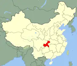
 | |
|---|---|---|
| Counties | ||
| Autonomous counties | ||
| Defunct divisions | ||
| Attractions |
| |
| Sports venues | ||
| Higher education | ||
| Culture & demographics | ||
| Transport | ||
| Economy | ||
28°59′08″N 106°55′41″E / 28.9856°N 106.928°E