Weil, Bavaria
Weil | |
|---|---|
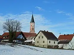 Weil seen from the south | |
 Coat of arms | |
Location of Weil within Landsberg am Lech district 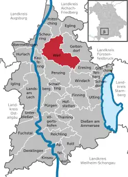 | |
 Weil  Weil | |
| Coordinates: 48°07′N 10°55′E / 48.117°N 10.917°E | |
| Country | Germany |
| State | Bavaria |
| Admin. region | Oberbayern |
| District | Landsberg am Lech |
| Subdivisions | 6 Ortsteile |
| Government | |
| • Mayor (2020–26) | Christian Bolz[1] |
| Area | |
• Total | 44.48 km2 (17.17 sq mi) |
| Elevation | 587 m (1,926 ft) |
| Population (2024-12-31)[2] | |
• Total | 4,022 |
| • Density | 90/km2 (230/sq mi) |
| Time zone | UTC+01:00 (CET) |
| • Summer (DST) | UTC+02:00 (CEST) |
| Postal codes | 86947 |
| Dialling codes | 08195 |
| Vehicle registration | LL |
| Website | https://www.weil.de/ |
Weil (German pronunciation: [vaɪl] ⓘ) is a municipality in the district of Landsberg in Bavaria in Germany.
World Heritage Site
It is home to one or more prehistoric pile-dwelling (or stilt house) settlements that are part of the Prehistoric Pile dwellings around the Alps UNESCO World Heritage Site.[3]
References
- ^ Liste der ersten Bürgermeister/Oberbürgermeister in kreisangehörigen Gemeinden, Bayerisches Landesamt für Statistik, 15 July 2021.
- ^ "Gemeinden, Kreise und Regierungsbezirke in Bayern, Einwohnerzahlen am 31. Dezember 2024; Basis Zensus 2022" [Municipalities, counties, and administrative districts in Bavaria; Based on the 2022 Census] (CSV) (in German). Bayerisches Landesamt für Statistik.
- ^ UNESCO World Heritage Site - Prehistoric Pile dwellings around the Alps
Towns and municipalities in Landsberg (district) | ||
|---|---|---|
|  | |