Werra-Suhl-Tal
Werra-Suhl-Tal | |
|---|---|
Location of Werra-Suhl-Tal within Wartburgkreis district 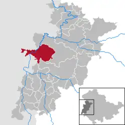 | |
 Werra-Suhl-Tal  Werra-Suhl-Tal | |
| Coordinates: 50°56′N 10°04′E / 50.933°N 10.067°E | |
| Country | Germany |
| State | Thuringia |
| District | Wartburgkreis |
| Subdivisions | 10 |
| Government | |
| • Mayor (2022–28) | Maik Klotzbach[1] |
| Area | |
• Total | 77.67 km2 (29.99 sq mi) |
| Elevation | 236 m (774 ft) |
| Population (2024-12-31)[2] | |
• Total | 6,028 |
| • Density | 78/km2 (200/sq mi) |
| Time zone | UTC+01:00 (CET) |
| • Summer (DST) | UTC+02:00 (CEST) |
| Postal codes | 99837 |
| Dialling codes | 036922, 036925 |
| Vehicle registration | WAK |
Werra-Suhl-Tal (German pronunciation: [vɛʁaˈzuːlˌtaːl], lit. 'Werra-Suhl-Valley') is a town and a municipality in the Wartburgkreis district of Thuringia, Germany. It was created on 1 January 2019 by the merger of the municipalities of Berka/Werra, Dankmarshausen, Dippach and Großensee. Its name refers to the rivers Werra, Suhl (Weihe) and Suhl (Werra).
References
- ^ Gewählte Bürgermeister - aktuelle Landesübersicht, Freistaat Thüringen, accessed 10 November 2022.
- ^ "Bevölkerung der Gemeinden vom Thüringer Landesamt für Statistik" (in German). Thüringer Landesamt für Statistik.