Westlake Village, Illinois
Westlake Village, Illinois | |
|---|---|
 Westlake Village  Westlake Village | |
| Coordinates: 42°18′40″N 89°17′26″W / 42.31111°N 89.29056°W | |
| Country | USA |
| State | Illinois |
| County | Winnebago |
| Townships | Pecatonica Burritt |
| Area | |
• Total | 1.05 sq mi (2.72 km2) |
| • Land | 0.92 sq mi (2.39 km2) |
| • Water | 0.13 sq mi (0.33 km2) |
| Elevation | 804 ft (245 m) |
| Population (2020) | |
• Total | 1,493 |
| • Density | 1,621.06/sq mi (625.75/km2) |
| Time zone | UTC-6 (Central (CST)) |
| • Summer (DST) | UTC-5 (CDT) |
| ZIP Code | 61088 (Winnebago) |
| Area codes | 815, 779 |
| FIPS code | 17-80570 |
| GNIS feature ID | 2806583[2] |
Westlake Village is a census-designated place (CDP) in Winnebago County, Illinois, United States. It is in the western part of the county, in the southeast part of Pecatonica Township, with a small portion extending east into Burritt Township. It is built around a golf course and a small reservoir (Westlake) on Coolidge Creek. It is 5 miles (8 km) northwest of the village of Winnebago and 11 miles (18 km) west-northwest of the city of Rockford.
Westlake Village was first listed as a CDP prior to the 2020 census.
Demographics
| Census | Pop. | Note | %± |
|---|---|---|---|
| 2020 | 1,493 | — | |
| U.S. Decennial Census[3] | |||
Westlake Village first appeared as a census designated place in the 2020 U.S. Census.[4]
Education
It is in the Pecatonica Community Unit School District 321.[5]
References
- ^ "2020 U.S. Gazetteer Files". United States Census Bureau. Retrieved March 15, 2022.
- ^ a b U.S. Geological Survey Geographic Names Information System: Westlake Village, Illinois
- ^ "Census of Population and Housing". Census.gov. Retrieved June 4, 2016.
- ^ "2020 Geography Changes". United States Census Bureau.
- ^ Geography Division (December 22, 2020). 2020 CENSUS - SCHOOL DISTRICT REFERENCE MAP: Winnebago County, IL (PDF) (Map). U.S. Census Bureau. Retrieved June 28, 2025. - Text list
External links
Municipalities and communities of Winnebago County, Illinois, United States | ||
|---|---|---|
| Cities | 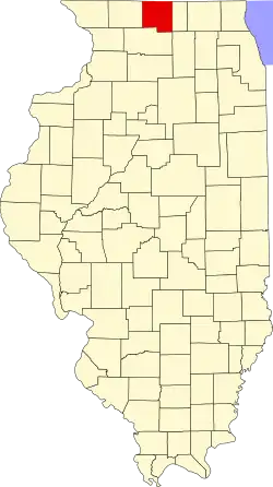 | |
| Villages | ||
| Townships | ||
| CDPs | ||
| Other communities | ||
| Footnotes | ‡This populated place also has portions in an adjacent county or counties | |