Weyib River
| Weyib River Gestro, Webi | |
|---|---|
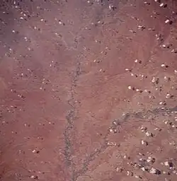 Gestro/Weyib River (right) and Ganale River (center) | |
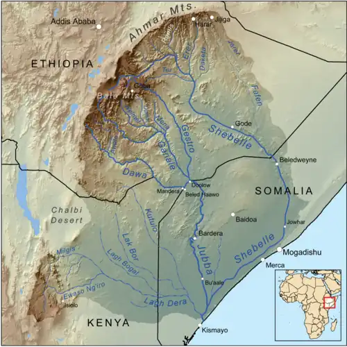 Map of the Jubba/Shebelle drainage basin with the Weyib River (Gestro) at the centre | |
| Location | |
| Country | Ethiopia |
| Regions | Somali, Oromia |
| Physical characteristics | |
| Source | |
| • location | Bale Mountains |
| • coordinates | 6°53′16″N 39°33′53″E / 6.88778°N 39.56472°E |
| • elevation | 3,709 m (12,169 ft) |
| Mouth | Ganale Dorya River |
• location | Near Dolobay |
• coordinates | 4°17′12″N 42°2′35″E / 4.28667°N 42.04306°E |
• elevation | 181 m (594 ft) |
| Length | 657 km (408 mi)[1] |
| Basin size | 24,861 km2 (9,599 sq mi)[1] |
| Discharge | |
| • location | Mouth[1] |
| • average | 66.3 m3/s (2,340 cu ft/s) |
| • minimum | 8.81 m3/s (311 cu ft/s) |
| • maximum | 205.8 m3/s (7,270 cu ft/s) |
| Basin features | |
| Progression | Ganale Dorya → Jubba → Somali Sea |
| River system | Jubba Basin |
| Landmarks | Sof Omar Caves |
| Population | 1,150,000[2] |
Weyib River (also Webi Gestro; Wabē Gestro or Webi River)[3] is a river of eastern Ethiopia. It rises in the Bale Mountains east of Goba in the Oromia Region, flowing east to pass through the Sof Omar Caves,[4] then to the southeast until it joins the Ganale Dorya River in the Somali Region.
See also
References
- ^ a b c Lehner, Bernhard; Verdin, Kristine; Jarvis, Andy (2008-03-04). "New Global Hydrography Derived From Spaceborne Elevation Data". Eos, Transactions American Geophysical Union. 89 (10): 93–94. doi:10.1029/2008eo100001. ISSN 0096-3941.
- ^ Liu, L., Cao, X., Li, S., & Jie, N. (2023). GlobPOP: A 31-year (1990-2020) global gridded population dataset generated by cluster analysis and statistical learning (1.0) [Data set]. Zenodo. https://doi.org/10.5281/zenodo.10088105
- ^ "Merriam-Webster's geographical dictionary"
- ^ "Encyclopedia of Caves and Karst Science"