Willard, Georgia
Willard | |
|---|---|
 Willard Location within the state of Georgia  Willard Willard (the United States) | |
| Coordinates: 33°18′26″N 83°29′2″W / 33.30722°N 83.48389°W | |
| Country | United States |
| State | Georgia |
| County | Putnam |
| Elevation | 554 ft (169 m) |
| Time zone | UTC-5 (Eastern (EST)) |
| • Summer (DST) | UTC-4 (EDT) |
| GNIS feature ID | 326414 |
Willard is an unincorporated community in western Putnam County, Georgia, United States. It lies along State Route 16 between Eatonton and Monticello[1] at an elevation of 554 feet (169 m).[2]
References
- ^ Rand McNally. The Road Atlas '05. Skokie: Rand McNally, 2005, p. 28.
- ^ U.S. Geological Survey Geographic Names Information System: Willard, Georgia, Geographic Names Information System, 1979-09-25. Accessed 2007-12-26.
Municipalities and communities of Putnam County, Georgia, United States | ||
|---|---|---|
| City | 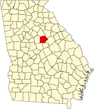 | |
| CDP | ||
| Unincorporated communities | ||
| Ghost town | ||